Download Mkgmap for Windows 7, 8, 10, 11 - An application that supports users to convert OpenStreetMap tags into maps in IMG format through a command line interface
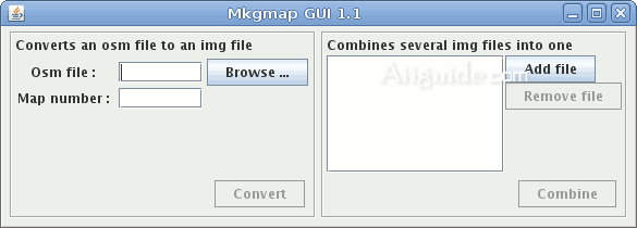
Mkgmap is an application that supports users to convert OpenStreetMap tags (abbreviated as OSM an online world map service with open content) into maps in IMG format through a command line interface, compatible with Garmin GPS device. To edit OpenStreetMap data you can use Java OpenStreetMap Editor with the ability to edit every detail in the map, besides Java OpenStreetMap Editor also allows you to view the map in many different modes, and can Map updates from OSM servers.
Mkgmap - Converts OpenStreetMap data into vector maps
Mkgmap also includes a help document that guides users step-by-step through the basics of working with Garmin GPS devices and the OpenStreetMap service. Mkgmap helps users gather essential information about the map type, learn how to design Garmin maps, and consider resolutions and levels.
Features of Mkgmap application:
- Generates a map directly from a file saved from JOSM or from an extract of the main OSM planet file.
- Converts several .osm files in one run of the program to create a map tile set.
- Creates a .tdb file and an overview map that can be used to view the maps in MapSource or QLandkarte.
- Creates a gmapsupp.img file that can be copied directly to an SD card.
- Can also combine previously produced .img files into one gmapsupp.img file.
- Create a .tdb and overview map from previously produced .img files.
- The mapping between OSM features features in the Garmin map can be customised.
- Transliteration of characters to ascii where that is possible to enable viewing on low end devices or for international maps.
- Character set can be specified for display on capable GPS devices.
- Control over the zoom levels that any feature appears at.


